top of page


未來韌性城市
Future Resilient City
Project 1.
未來都會區淹水暴露度模擬
Future Urban Flood Exposure Simulation
本研究針對都會區土地利用變遷與洪水暴露之關聯,建構整合式模擬架構。透過代理人基礎模型(Agent-Based Model)模擬不同氣候與社會經濟情境下的未來土地利用發展,並結合淹水模擬分析,量化不同洪水事件下的暴露範圍與程度。同時藉由敏感度分析、校準與驗證提升模型可信度,以支援都市成長管理與未來洪災風險規劃。
This study integrates an Agent-Based Model with flood inundation analysis to simulate future metropolitan land-use change and quantify flood exposure under different scenarios. Model calibration, validation, and sensitivity analysis are applied to support urban growth and flood-risk planning.

整合式模擬架構
Integrated simulation framework
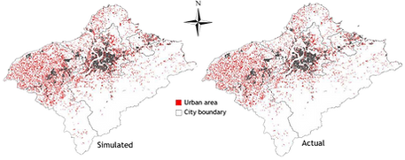
2015年模擬與實際土地利用型態
Simulated and actual land-use patterns in 2015
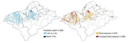
2015年與2030年模擬洪水暴露度
Simulated flood exposure in 2015 and 2030
Project 2.
低衝擊開發之減洪效益
Low Impact Development for Urban Flood
本研究從都市尺度探討新舊市區不同空間型態下低衝擊開發(LID)策略的減洪效益,透過風險地圖辨識淹水風險成因,並設計三種情境進行比較。結果顯示,LID可在有限都市空間中有效降低逕流並延緩洪峰。
This study evaluates the flood mitigation benefits of Low Impact Development (LID) strategies at the urban scale by comparing different spatial forms in old and newly developed urban areas. Flood risk factors are identified through risk mapping, and three LID scenarios are assessed. The results show that LID can effectively reduce runoff and delay peak flows within limited urban space.

綠化屋頂
Rooftop Greening
透水鋪面
Permeable Surface
雨水花園
Rain Garden

減緩效果模擬結果 Simulation results of the mitigation effects
Project 3.
土地利用變遷與碳排放模擬
Land-Use Change and Carbon Emissions
本研究建構整合性模型預測未來土地利用變遷,並透過多重發展情境模擬,解析台北都會區電力碳排放的空間動態。研究結果揭示,都市邊緣區將是承載未來碳排放擴散與衝擊的關鍵邊界。本研究成果可為前瞻性土地使用規劃與低碳城鄉治理提供重要的空間科學依據。
This study develops an integrated analytical framework to simulate future land-use dynamics and evaluate the spatial patterns of electricity-related carbon emissions across the Taipei Metropolitan Area under diverse scenarios. The findings highlight peri-urban fringes as critical vulnerability hotspots subject to future carbon diffusion. Ultimately, this research provides spatial science-based evidence to inform proactive land-use planning and low-carbon urban governance strategies.

模型架構圖 Model Framework


未來情境碳排放空間分布
Spatial Distribution of Future Carbon Emissions
Project 4.
山崩災害治理區位整合評估
Landslide Governance Assessment
本研究建構整合災害潛勢與地方災前準備能力之分析架構。首先以歷年山崩資料及地形、地質、降雨、土地利用等因子,運用隨機森林建立山崩發生機率模型,並結合 GIS 進行空間分析;其次透過問卷評估居民防災準備與調適能力,並以因素分析、熵值法及 TOPSIS 進行綜合評估。最終整合自然災害風險與地方防災能力,辨識治理與資源投入之優先區位。
This study develops an integrated framework combining hazard potential and local disaster preparedness. A Random Forest model estimates landslide probability, while surveys assess residents’ preparedness and adaptive capacity. GIS, factor analysis, entropy weighting, and TOPSIS are then applied to identify priority areas for disaster governance and resource allocation.
自然衝擊模型結果
Natural Disaster Model
社會韌性分析
Social Resilience Analysis
空間治理分布
Spatial Governance


以隨機森林預測山崩發生機率。
Using Random Forest to predict landslide occurrence probability.
使用地圖式問卷平台蒐集防災整備資料,並將李克特量表的回應進行空間量化與製圖。
A map based survey platform was used to collect preparedness data, with Likert scale responses spatially quantified and mapped
根據災害發生機率與居民防災整備程度之間的落差,以 TOPSIS 整合並瞭解資源投入區位。
Based on the gap between disaster occurrence probability and residents’ preparedness, TOPSIS is applied to integrate the indicators and identify priority areas for resource allocation.
bottom of page